


Water Pressure and Floods Around Gunja – Lessons for Water Management
Events such as the flooding around Gunja, caused by dike breaches after heavy rainfall and resulting in the displacement of many residents from their homes, have shown that water management in Croatia has not been at a satisfactory level.
This is primarily because the technology currently used in Croatia is simply not suitable for preventive water management, and methods for measuring and mapping water bodies still mainly rely on classical terrestrial geodetic approaches. These include poles, prisms, and total stations, which require access to the sea or riverbed—something that is often not feasible in reality. Additionally, due to technical challenges, measurements are often not carried out regularly, which increases the risk of flooding.
Advanced Technology
On the other hand, with the new technology that applies remote sensing methods such as LiDAR (Light Detection and Ranging) scanning, thermographic inspections, and other techniques, combined with the creation of “digital twins” of seas, coasts, rivers, lakes, and other water bodies, Geometricus can provide dynamic support for monitoring and maintaining water bodies, thereby helping to prevent future floods.
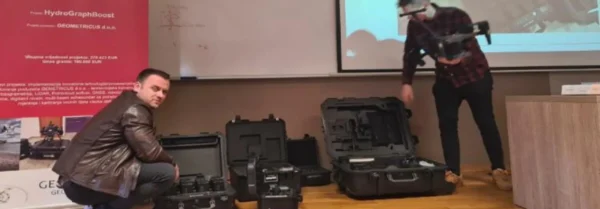
In March 2023, the University of North, Varaždin, hosted Geometricus representatives who presented this cutting-edge technology, primarily to geodesy students, preparing them for the future of their profession, which is already unfolding.
Supported by Norway Grants
To acquire the necessary equipment, Geometricus applied for funding under the Business Development and Innovation Program of Norway Grants in Croatia and received support amounting to €190,000.
The project is expected to result in a 77% increase in the company’s operational revenues and a 10% increase in operational profit by 2026, alongside the creation of six new jobs.
Author: Egli Ilic
